It’s nice to find out that there are still mysteries left in this world, let alone ones that are visible from space. On the southeast corner of Hudson Bay, the coastline traces a near perfect arc, roughly concentric on another ring of islands in the bay. So, what caused it? The obvious answer, proposed in the 1950s, is that it’s the remnants of a large impact crater. Apparently, however, there is none of the usual geologic evidence for this, and over the past 50 years, there has been debate on its origins. From other sites I’ve read, many geologists seem to have concluded that it is a depression caused by glacial load during the ice age, though a recent conference paper (2006) argues that it may indeed be a crater. The current thinking is summarized nicely on this web page:
There is fairly extensive information on this in Meteorite Craters by Kathleen Mark, University Press, isbn 0-8165-1568-9 (paperback). The feature is known as the Nastapoka Arc, and has been compared to Mare Crisium on the Moon. There is “missing evidence,” which suggests that it isn’t an impact structure, however: “Negative results were . . . reached by R. S. Dietz and J. P. Barringer in 1973 in a search for evidence of impact in the region of the Hudson Bay arc. They found no shatter cones, no suevite or unusual melt rocks, no radial faults or fractures, and no metamorphic effects. They pointed out that these negative results did not disprove an impact origin for the arc, but they felt that such an origin appeared unlikely.” (p. 228)
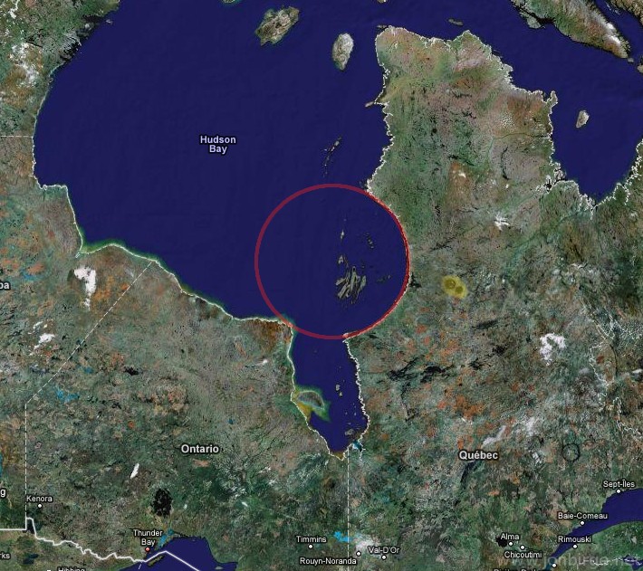
I know next to nothing about geology, but in the spirit of rank amateur naturalists that came before me, I won’t let that stop me from forming an opinion. In physics, whenever you see something that is symmetric about a point, you have to wonder about what is so special about the center of that circle; could it really be chance that roughly 800 miles of coastline all aim at the same point? If not, what defined that point? One explanation for how large circular formations are created is that they start as small, point-like features that get expanded over eons by erosion. In other words, the original sink-hole that started to erode is what defines the center of the improbable circle. There are also lots of physical phenomena that makes circles, such as deposition and flow of viscous materials from a starting point, assuming isotropic (spatially uniform) physical conditions everywhere. However, the planet is not isotropic. In fact, you can see plenty of arc-like features on coastlines and basins visible from satellite photos, and I can’t find a single one that is even close to as geometrically perfect as the Hudson Bay arc. If you overlay a perfect circle on Hudson Bay, as I’ve done in the picture, you see that it is nearly a perfect circle. How would erosion, or a glacial depression, manage to yield such a perfect geometry over such a large scale? Is it possible for the earth to be that homogeneous over such a large distance, and over the geologic span of time required to create it? To my untrained eye, at least, it screams single localized event.
If so, it would’ve been a major event, on par (at least based on size) with the impact site that is credited with putting a cap on the Cretaceous Period and offing the dinosaurs. On the other hand, this fact only serves to heighten the mystery, as you’d think there would be global sedimentary evidence for it. Whether the arc is the result of one of the biggest catastrophic events in earth’s history, or an example of nature somehow managing to create a near perfect circle the size of New York State by processes acting over unimaginably long spans of time, its mere existence is absolutely fascinating.